Climate change -Sea level rise and coastal flooding

Status: There are many unknowns about the magnitude and impacts of climate change

Climate change is widely accepted as a real threat to the future of the Earth, with impacts from this process being seen and felt over recent years, and these being potentially hastened by ongoing, damaging, human activities. Sea-level rise is one of the most widely known impacts of climate change, the result of melting ice, thermal expansion, and the reduction in post-glacial rebound. This climate change impact of sea-level rise also increases the risk of coastal flooding, an issue which can damage a variety of socio-economic aspects, putting property, communities, heritage, tourism, infrastructure, and other factors at risk. 

Climate change will also have knock on effects. For example, climate change is projected to increase severe weather conditions such as wind and storms. Severe windy weather, and changes in the wind direction, can cause waves to increase in size, or alter wave direction. As a result coastal areas less prepared for wave damage may be hit by waves from a different direction, or severe wave conditions. In turn, the coast, property, heritage sites, and other features may be damaged.

The Solway will be most significantly effected by increased flooding risk as a result of climate change according to a recent NatureScot report, as a result of the combined impacts of sea level rise, increased rainfall, and storm surges (Land Use Consultants, 2011). Flooding is exacerbated by the effect climate change will have on intertidal habitats which work as natural flood defences. See Climate change – impacts on marine life and processes for more information on intertidal habitats in the Solway and climate change.

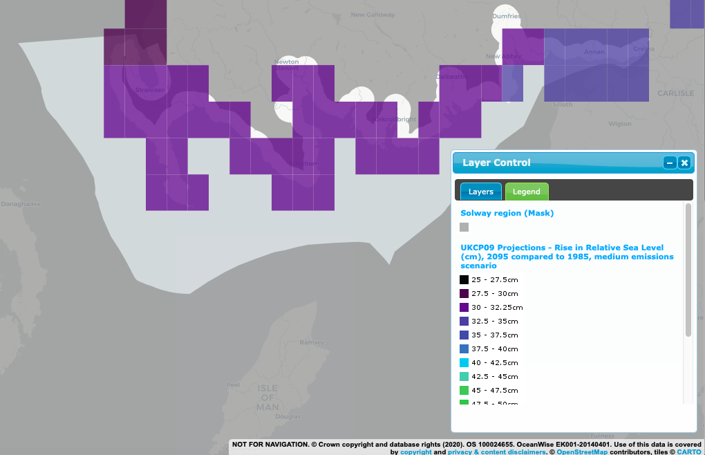
The Intergovernmental Panel on Climate Change (IPCC) is a scientific body under the United Nations. The IPCC produces, among other outputs, an Assessment Report, which provides a comprehensive assessment of global climate change and findings compiled from three working groups. Most recently the fifth Assessment Report was published, in 2014, with the sixth Assessment Report currently being worked towards, and aiming to be published in early 2022. Part of this report looks at global sea level rise projections for different emissions scenarios, i.e. different levels of emissions of carbon dioxide and other greenhouse gases into the atmosphere. These global scenarios are translated into the more detailed UK Climate Projections (UKCP). The UK Climate Projections 2018 (UKCP18) have updated predictions which were previously illustrated in 2009 (UKCP09), and follows the historic progress of the Paris Agreement, the first legally binding global climate deal in December 2015.

UKCP18 marine projections are summarised in the Headline Findings Report, with the overarching point being; that under every emissions scenario, sea level will continue to rise until 2100 around the UK.

Headline Marine Projections;

  • Sea level rise is occurring more in the south of the UK than in the north.
  • The rise in sea level will result in extreme coastal water levels.
  • The severity of sea level rise will be dependent on the severity of emissions, with the severity increasing relative to increasing emissions. Estimates for UKCP18 looked at exploratory sea level rise models until 2300, with rising levels beyond 2100.
  • Despite projected sea level rises being greater in UKCP18 than in UKCP09, adaptation planning has already factored in these higher projections.
    (Met Office, n.d. -a)

The UK leads the world in tackling climate change. Since 1990, emissions have been cut by more than 40%, whilst the economy has grown by more than two thirds. This is the best performance on a per person basis than any other G7 (Group of the seven countries with the largest economies in the World) nation. The UK is decarbonising faster than any other G20  (Group of twenty countries with the largest economies in the World) nation.

In 2018 the second National Adaptation Programme by the UK Government, the National Adaptation Programme and the third strategy for climate adaptation reporting  was published. This report sets out challenges and benefits of the impacts of climate change and how they will be managed, in response to the second Climate Change Risk Assessment (CCRA) and as part of the Climate Change Act 2008‘s five year cycle. The National Adaptation Programme, however, is focussed on England and reserved matters for the whole of the UK. Scotland has its own adaptation programme, under the requirements of the Climate Change (Scotland) Act 2009 to address the risks identified in the CCRA. The second round of which has recently finished consultations on the draft (April 2019). It aims of being published in later 2019, the Scottish Climate Change Adaptation Programme 2019-2024. Drafting was aided by Scotland’s National Coastal Change Assessment, among other projects and policies.

It is advised to read the Solway Review section on; Climate Change – Impacts on Marine life and Processes to gain additional insight into the impacts of climate change. Sea level rise and coastal flooding is only one of the many potential impacts climate change may bring about.


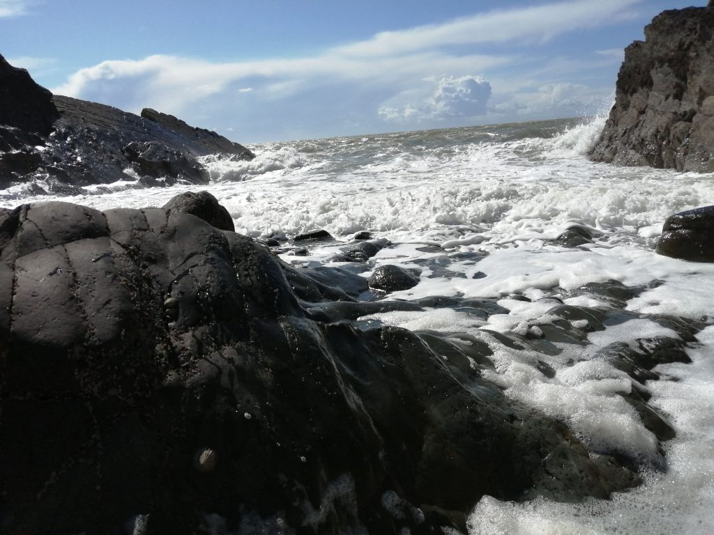
Image; Waves at Balcary on a calm day. © G. Reid/ Solway Firth Partnership

Climate change -Sea level rise and coastal flooding

Sea level rise, storm surges and rising temperatures

The rising temperatures contribute to sea level rise by melting ice (such as glaciers and ice caps) and through thermal expansion. Predictions suggest that sea level rise will accelerate, causing increased concern for the resulting impacts. This rise may influence tidal dynamics, in addition to the changes in water salinity, while adding to the global volume of water contained in the seas.

The funnel-shaped Solway Firth formed during the retreat of the ice sheets following the last glaciation which began to melt roughly 20,000 years ago, post-glacial sea level rise and fluvial erosion. Therefore the Solway is slowly rising in response to isostatic uplift, which will gradually reduce the storage capacity of the estuary. This process occurs gradually and is decreasing as time progresses, with the fastest rise seen in the time immediately following deglaciation. Rebound is no longer offsetting global sea-level rise, with sea level rise around the UK rising up to 2mm per year compared to uplift which is now less than 0.6mm per year (NatureSot, n.d.).

You can use the UK Climate Projections User Interface from the Met Office to generate projections from around the UK for sea level rise based on the different scenarios. You must create an account to do so, however it is free to use. For marine projections these can be explored for 2007- 2100, or 2007-2300, creating an output data subset or plume plot for Representative Concentration Pathway (RCP) 2.6, RCP 4.5, or RCP 8.5 which are 3 of the emissions scenarios used to predict change going forward. RCPs are essentially the scenarios of climate warming scenarios which are used to predict that changes we would see as a result, for example RCP 2.6 represents a change of between 0.9 and 2.3 degrees Celsius by 2081 -2100, whereas RCP 8.5 represents a warming of between 3.2 and 5.4 degrees Celsius by 2081 -2100 (Met Office, 2018).

A storm can result in a storm surge, where the sea level is far greater than predicted levels due to winds from a storm. The severity of the storm surge is dependent on many factors such as; the strength of the winds pushing the sea water onto the coast, the bathymetry of the seabed, and ‘a smaller contribution from the low pressure at the centre of the storm “pulling” the water level up, by about 1 cm for every 1 millibar change in pressure.’ (Met Office, n.d. -b).

Despite the proof of increasing temperatures there is a lack of agreement in whether or not this will result in increased wave hight and storminess. A recent paper delves into the 2013/2014 winter wave height on the Atlantic coast, and the erosion which occurred as a result (Masselink et al, 2016). This paper describes how the 2013/14 winter saw extensive coastal erosion and other impacts due to storm conditions, and ‘was the most energetic winter along most of the Atlantic coast of Europe since at least 1948‘. Comparing the 2013/14 winter to the previous 67 winters (from 1948 to 2015) this paper concluded that the wave conditions experienced for most of the Atlantic European seaboard were around 40% higher than the average conditions seen in winters prior. This report also warns future planning along the coast in Atlantic Europe to factor in the potential for more frequent, more intense storms, as well as outlining some studies which potentially link the increase in Atlantic storminess to climate change.


Defences

The Solway coast already features a variety of official, unofficial, and natural coastal flood defences. Coastal defences range in type along the coastline, with groynes, stepped or vertical concrete walls, revetments, rock armour, and other defence types, all featuring along the Solway. The Cumbria Coastal Strategy (discussed in Coastal Change) lists all current defences, at the time of writing the technical appraisals for each policy area, along with the condition and residual life of the asset. All technical appraisal reports for the entire Solway Cumbrian coastline (Cell 11e) are available here. The Scottish side of the Firth often features rock armour to try to protect coastal settlements from erosion, such as Southerness and Carsethorn. In 2021, new plans for rock armour coastal defences at Carsethorn, joining existing rock armour defences in the same style, have been lodged with the council (Daily Record, 2021). Ad-hoc coastal defences are sometimes undertaken by landowners to protect land or assets, often from soil and rubble as seen at Redkirk Point.

Some intertidal habitats such as saltmarsh have natural flood defence capabilities, helping to disperse wave action, reducing the power of waves. The erosion of these habitats could compound the issues of sea level rise and increase storminess leading to an increase in coastal flooding landward of these intertidal habitats. See Climate change – impacts on marine life and processes for more on climate change and intertidal habitats. 


Image; Scotland’s National Marine Plan Interactive, with layers (links will provide usage licence, data provider, etc); ‘Solway Region (mask)© Crown Copyright, All rights reserved, and ‘UKCP09 Projections – Rise in Relative Sea Level (cm), 2095 compared to 1985, medium emissions scenario‘ © Crown Copyright 2009. The UK Climate Projections (UKCP09) have been made available by the Department for Environment, Food and Rural Affairs (Defra) and the Department of Energy and Climate Change (DECC) under licence from the Met Office, UKCIP, British Atmospheric Data Centre, Newcastle University, University of East Anglia, Environment Agency, Tyndall Centre and Proudman Oceanographic Laboratory. These organisations give no warranties, express or implied, as to the accuracy of the UKCP09 and do not accept any liability for loss or damage, which may arise from reliance upon the UKCP09 and any use of the UKCP09 is undertaken entirely at the users risk.

Climate change -Sea level rise and coastal flooding

Scotland's flood risk management

With more water being added to the water cycle through rising sea levels and warmer temperatures increasing evaporation resulting, in part, in heavy rainfall and coastal vulnerability, the risk of flooding is increasing.

Scottish Planning Policy principles factor climate change mitigation, adaptation and flood risk into guiding factors to be considered in development decisions within the principle policy in favour of sustainable development. This document also outlines that development plans should take the precautionary approach to coastal flooding, and that there will not be support for new developments which require man-made coastal flooding defences, unless justifiable. These policies look to limit additional properties at risk of flooding in the future from a terrestrial development perspective.

The Flood Risk Management (Scotland) Act 2009 implements the Directive 2007/60/EC on the assessment and management of flood risks, and aims to reduce the potentially vast impacts of flooding

The Scottish Environmental Protection Agency (SEPA) is responsible for the creation of the National Flood Risk Assessment (NFRA) which was most recently published in 2018 (with the prior assessment conducted in 2011). SEPA uses annually updated flood maps which ‘have been supplemented by information given by local authorities and Scottish Water, to identify what is at risk of river, coastal and surface water flooding‘ (Scottish Environmental Protection Agency, n.d.). This allows SEPA to identify Potentially Vulnerable Areas (PVAs), which are at risk from flooding impact on environmental, economic, or historical aspects. The NFRA provides a high-level view of the risks of flooding to assist in managing these risks.

In 2015 SEPA also published a Flood Risk Management Strategy (FRMS) for the Solway Local Plan District. SEPA created a separate strategy for each of the 14 Scottish Local Plan Districts, working in collaboration with others. These strategies coordinate flood management efforts by outlining high risk areas, the reasons for flooding in these areas and the resulting impact floods will have. Decisions can therefore be made on the basis of sound information. The FRMS for the Solway also provides an overview for the flooding risk from the Solway, which estimates 3,900 residential and 900 non-residential properties at risk of flooding, but only 20% of which are at risk of coastal flooding, with the river Nith being a frequent cause of river flooding from tidal surges, surface water, and storms (Scottish Environmental Protection Agency, 2015).

It is worth noting that there was a change in the way buildings are counted in the new NFRA compared to the older versions of the NFRA and FRMS. Previously, a single address with multiple buildings would only have one point marking its centre point and the flood risk was assessed for that point. Now, each building will be considered individually making the assessment of flood risk more effective. For example, universities consist of many different buildings, some of which may be more at risk of flooding than others, and now their risk will be considered for each building rather than the entire campus as one unit.

Dumfries and Galloway Council, SEPA, Scottish Water and other partners worked together in publishing the Solway Local Flood Risk Management Plan (LFRMP) in 2016, describing how flood risk is to be managed between 2016 and 2022. The creation of a LFRMP is a requirement under the Flood Risk Management (Scotland) Act 2009, to supplement the FRMP. The Council is responsible for the construction and maintenance of flood defences in the area.

Dumfries and Galloway Council, on behalf of all partners, published an Interim Report in February 2019 on the Solway LFRMP, which is also required by the 2009 Act. This report assesses the progress made since the creation of the 2016 plan in pursuing the risk management measures identified in the plan as well as measures budgets and revisions if necessary.

The second round of plans will be published in 2021 and 2022 for the FRMS and LFRMP respectively, and the NFRA will be reviewed and updated every 6 years, next publishing the third iteration. 

Dumfries and Galloway also has a non-statutory Shoreline Management Plan (SMP), published in 2005, which is used in developing a coastal defence strategy, considering defence methods and locations to best suit the needs of the area, maximising the benefit seen for the cost. Dumfries and Galloway Council are currently in the process of creating a new SMP.

Dumfries and Galloway Council also assess the risk of flooding in vulnerable areas and consider flood protection work in those areas. Various flood studies and schemes are available through Dumfries and Galloway Council and range in focus, such as causes, potential flood risk, potential flood risk management options, review current defences. These studies and schemes are available here.


Image; Port Logan © G. Reid/ Solway Firth Partnership

Climate change -Sea level rise and coastal flooding

England's flood risk management

The area of Cumbria along the coast of the Solway in England is at high risk of floods not only from the coast but also inland flooding, sometimes as the result of coastal water levels impeding river flows and causing floods up stream.

The Department for Environment, Food & Rural Affairs (DEFRA) has the national responsibility for policy making powers in England for flood and coastal erosion risk management and is also the department which provides funding for flood and coastal erosion risk management.

The Environment Agency (EA) is responsible for managing the risk of flooding from the sea and main rivers, and also for regulating the safety of reservoirs. Where there is an interface between the sea and main rivers with local flood risk sources (for example, tide locking) it is the responsibility of the Lead Local Flood Authority (Cumbria County Council) to consider the impacts and consequences. The EA published the National flood and coastal erosion risk management strategy for England (NFCERMSE) in 2020, as per the Flood and Water Management Act 2010, which provides an overarching framework for local authorities to work with when approaching local flood risk. 

As part of the Flood and Water Management Act 2010, s.19 the Lead Local Flood Authority must investigate risk management authorities which have relevant management functions and if those functions have been exercised. The flood investigations are available for Carlisle, Allerdale, and Copeland areas.

Formed under the Flood and Water Management Act 2010 are Regional Flood and Coastal Committees (RFCC) in England. The EA must consult with the relevant RFCC before conducting flood related work within the committee’s region. Members of these committees have experience relevant to flood risk management, are independent, and are appointed by the Lead Local Flood Authority. The coast of the Solway entirely falls under the North West Regional Flood and Coastal Committee, which seeks to achieve three broad goals, coherent risk management, financially efficient risk management and to connect different groups and bodies (such as the Lead Local Flood Authority and EA) to develop flood and coastal risk management knowledge and understanding.

The North West and North Wales Coastal Group is comprised of local authorities, the Environment Agency and other organisations who manage the coastline from Great Orme’s Head in Wales to the border with Scotland at the Solway Firth and produces the Shoreline Management Plan for this area.
This group reports to the North West Regional Flood and Coastal Committee.

In England the North West England and North Wales Shoreline Management Plan region is split into 5 separate sub-cells, one being sub-cell 11e, covering St Bees Head to the Scottish Border, the entirety of the English side of the Solway Firth coast.

In England, local authorities lead on the management of local flood risk, with the support of the relevant organisations. Cumbria County Council has an established role in local flooding as Lead Local Flood Authority for Cumbria under the Flood and Water Management Act 2010, with responsibility for developing, maintaining and applying a local flood risk strategy. The Council has new powers and duties for managing flooding from local sources within the Cumbrian administrative area, these are namely: ordinary watercourses, surface water (overland runoff) and groundwater

The County Council has, therefore, published the Local Flood Risk Management Strategy, most recently published in 2015, to set out how local flood risks will be managed in the county, who will deliver them and how they might be funded, as well as an Action Plan for the programme of work. The Strategy follows the principles set out in the NFCERMSE and was produced in collaboration with the EA, District and Borough Councils, United Utilities and other bodies referred to in the 2010 Act as Risk Management Authorities.

Coastal flooding is not specifically managed within this Strategy, however local forms of flooding will be impacted or exacerbated by coastal flooding and these will be addressed by the local Strategy. 

Coastal erosion and flooding risk management is tackled separately, in the Shoreline Management Plans, based on the strategy laid out in the NFCERMSE, and produced by the EA and coastal districts (see Coastal change).

Local community flood action groups have been established in Workington and Flimby.

Local information for floods is available from the relevant county/city council, for CarlisleAllerdale, and Copeland.


Image; Silloth. © Solway Firth Partnership

Climate change -Sea level rise and coastal flooding

References

Adaptation sub-committee (2016) UK Climate Change Risk Assessment (2017). Evidence Report – Summary for Scotland, Adaptation Sub-Committee on Climate Change, London. Available here. (Accessed: 14.05.18)

Barbier, E. B., Hacker, S. D., Kennedy, C., Koch, E. W., Stier, A. C., & Silliman, B. R. (2011). The value of estuarine and coastal ecosystem services. Ecological monographs, 81(2), 169-193. Available here. (Accessed: 13.08.19)

Baxter, J.M., Boyd, I.L., Cox, M., Donald, A.E., Malcolm, S.J., Miles, H., Miller, B., Moffat, C.F., (Editors), (2011). Scotland’s Marine Atlas: Information for the national marine plan. Marine Scotland, Edinburgh. pp 191. Available here. (Accessed 22.07.19)

CREW, Centre of Expertise for Waters (2012). Coastal flooding in Scotland: A guidance document for coastal practitioners. Available here. (Accessed 25.07.19)

Cumbria County Council (2015). Local Flood Risk Management Strategy. Available here. (Accessed: 14.05.18)

Department for Environment, Food and Rural Affairs (2018). The National Adaptation Programme and the Third Strategy for Climate Adaptation Reporting, Making the country resilient to a changing climate. Available here. (Accessed: 23.07.19)

Dumfries and Galloway Council (2016). Solway Local Plan District. Local Flood Risk Management Plan. Available here. (Accessed: 14.05.18)

Dumfries and Galloway Council (2019). Solway Local Plan District. Local Flood Risk Management Plan. Interim Report. Available here. (Accessed: 14.05.18)

Dynamic Coast, Scotland’s National Coastal Change Assessment (n.d.). Available here. (Accessed: 11.05.18)

Environment Agency (2014). Flood and coastal erosion risk management, Long-term investment scenarios (LTIS). Available here. (Accessed: 25.07.19)

Environment Agency (2020). National Flood and Coastal Erosion Risk Management Strategy for England. Available here. (Accessed: 24.08.20)

Firth, C. R., Collins, P. E., Smith, D. E., & NatureScot. (2000). Focus on Firths: Coastal Landforms, Processes and Management Options; the Solway Firth. NatureScot.

Hansom, J., Maxwell, F., Naylor, L., & Piedra, M. (2017). Impacts of Sea-Level Rise and Storm Surges Due to Climate Change in the Firth of Clyde. NatureScot Commissioned Report No. 891. Available here. (Accessed: 13.08.19)

HR Wallingford Limited (2005). Dumfries and Galloway Shoreline Management Plan, Study: Stage 1, Volume 1, Report EX 4963 Rev 2.0. Available here. (Accessed 22.07.19)

Idier, D., Paris, F., Le Cozannet, G., Boulahya, F., & Dumas, F. (2017). Sea-level rise impacts on the tides of the European Shelf. Continental Shelf Research, 137, 56-71. Available here. (Accessed: 13.08.19)

Intergovernmental Panel on Climate Change (2014). Climate Change 2014: Synthesis Report. Contribution of Working Groups I, II and III to the Fifth Assessment Report of the Intergovernmental Panel on Climate Change [Core Writing Team, R.K. Pachauri and L.A. Meyer (eds.)]. IPCC, Geneva, Switzerland, 151 pp. Available here. (Accessed 16.07.19)

Marine Climate Change Impacts Partnership (n.d.). Marine Climate Change Impacts Report Cards. Available here. (Accessed: 14.07.19)

Marine Management Organisation. (n.d.). Marine Planning Evidence Base. Available here. (Accessed: 14.05.18)

Marine Scotland (n.d.). Scotland’s National Marine Plan Interactive. Available here. (Accessed: 25.07.19)

Met Office (n.d.). UKCP18 Marine Climate Change Infographic. Available here. (Accessed 16.07.19)

Mills, F., Sheridan, S. and Brown S., (2017). Clyde Marine Region Assessment. Clyde Marine Planning Partnership. pp 231. Available here. (Accessed: 18.06.18)

Sabatino, A. D., Murray, R. B. H., Hills, A., Speirs, D. C., & Heath, M. R. (2016). Modelling sea level surges in the Firth of Clyde, a fjordic embayment in south-west Scotland. Natural Hazards, 84(3), 1601-1623. Available here. (Accessed: 13.08.19)

Scottish Government (2014). Scottish Planning Policy. Available here. (Accessed: 12.08.19)

Solway Firth Partnership (1996). The Solway Firth Review, Solway Firth Partnership, Dumfries. Available here. (Accessed 23.07.19)

UK National Ecosystem Assessment (2011). The UK National Ecosystem Assessment: Technical Report. UNEP-WCMC, Cambridge. Available here. (Accessed: 24.07.19)

United Nations (2016). Paris Agreement. Paris: United Nations, pp.1-27. Available here. (Accessed 25.07.19)


In Text References;

Daily Record (2021). Carsethorn residents set to benefit from installation of vital sea defences. Available here. (Accessed: 01.04.21)

Land Use Consultants (2011). An assessment of the impacts of climate change on Scottish landscapes and their contribution to quality of life: Phase 1 – Final report. NatureScot Commissioned Report No. 488. Available here. (Accessed: 07.08.19)

Masselink, G., Castelle, B., Scott, T., Dodet, G., Suanez, S., Jackson, D., & Floc’h, F. (2016). Extreme wave activity during 2013/2014 winter and morphological impacts along the Atlantic coast of Europe. Geophysical Research Letters, 43(5), 2135-2143. Available here. (Accessed: 13.08.19)

Met Office (2018). UKCP18 Guidance: Representative Concentration Pathways. Available here. (Accessed: 11.11.20)

Met Office (n.d. -a). Headline Findings Report on UKCP18. Available here. (Accessed 16.07.19)

Met Office (n.d.-b). Storm surge. Available here. (Accessed: 14.05.18)

NatureScot (n.d.) Present and Future Sea Levels. Available here. (Accessed: 11.11.20)

Scottish Environmental Protection Agency (2015). Flood Risk Management Strategy, Solway Local Plan District. Available here. (Accessed: 19.07.19)

Scottish Environmental Protection Agency (n.d.). National Flood Risk Assessment Data Explorer Tool. ‘What is the NFRA?’ Available here. (Accessed: 24.07.19)


Image; Blitterlees looking towards Scotland. © Solway Firth Partnership