Water circulation

Status: Purely descriptive 

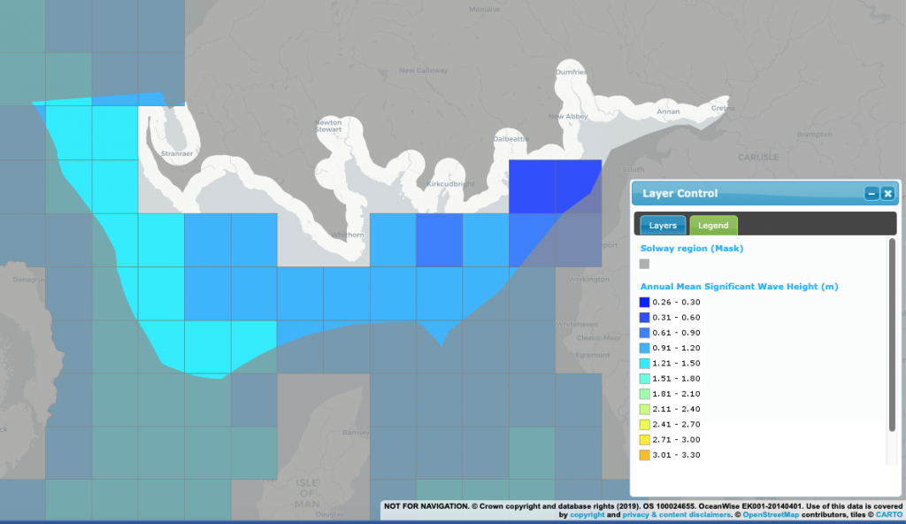
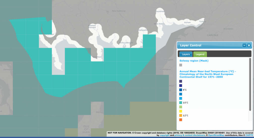
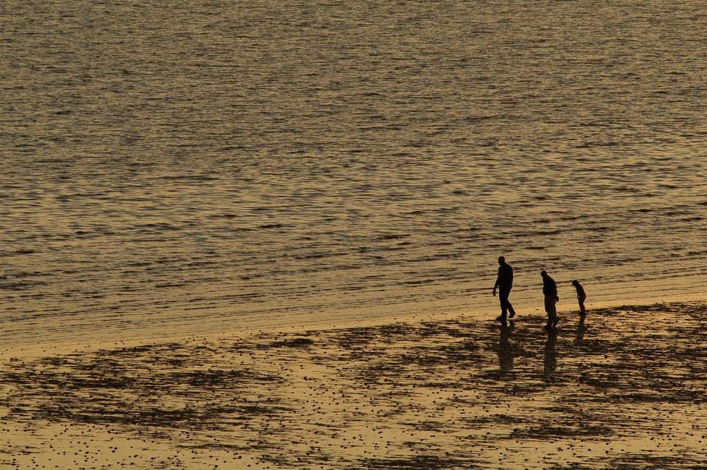
Water circulation is the natural movement and mixing of water. Common features which effect the pattern of circulation are the temperature and salinity of sea water. These factors alter the waters density and allow, for example, warmer water to circulate above colder water, and freshwater from rivers will float above salty seawater. Tides are also a major factor in water circulation, however circulation can also be altered by rivers entering the estuary, as well as weather focussed phenomenon such as rain, wind, storms, and air pressure.

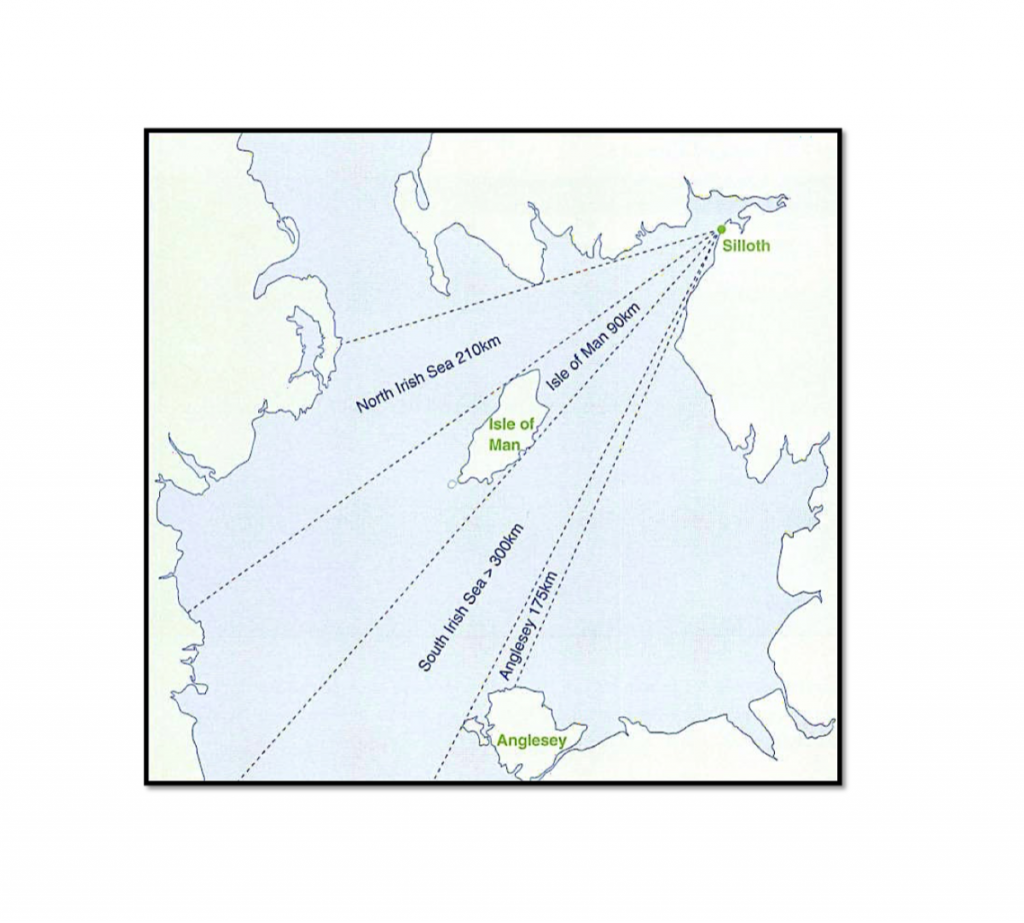
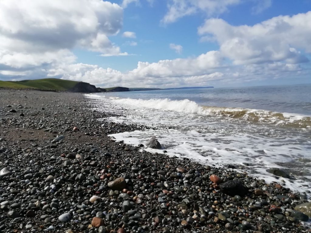
The Solway Firth is one of Scotland’s major estuaries with an area of around 300km2. Being on the west side of Scotland/England the Firth includes the boundary between these two UK countries and follows roughly the same orientation as the Isle of Man throughout the majority of its area, in a southwest/northeast direction. As the Solway narrows it orientates to a more East/West direction, before splitting into the River Eden and the Channel of River Esk. These are just two of the rivers which feed into the Solway, others include the Scottish; Annan, Nith, Dee, and Cree, and the English; Waver, Wampool, and the Sark which forms the beginning of the Scottish/English land border as it progresses inland.

‘Hydrological conditions’ such as the salinity and sea surface temperature of the marine area around the UK are assessed in relation to meeting the high level UK ‘Good Environmental Status’ (GEnvS) objective that; “The nature and scale of any permanent changes to hydrographical conditions resulting from anthropogenic activities do not have significant long term impacts on UK habitats and species” (Department for Environment, Food and Rural Affairs, 2019). Hydrological conditions are one of eleven ‘descriptors’ used to describe what GEnvS will look like in the Marine Strategy Framework Directive. These descriptors help member states interpret GEnvS for their waters. As of the recent, 2019, updated assessment for the UK Marine Strategy Part One, GEnvS was continuing to be achieved for hydrological conditions in the UK. 


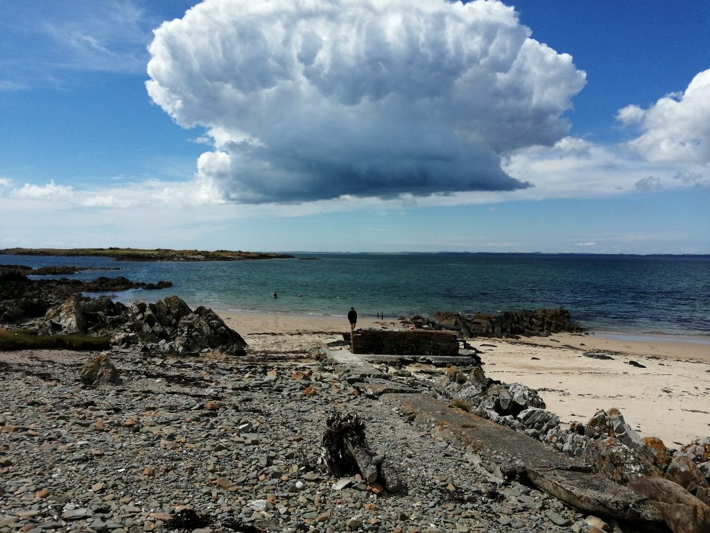
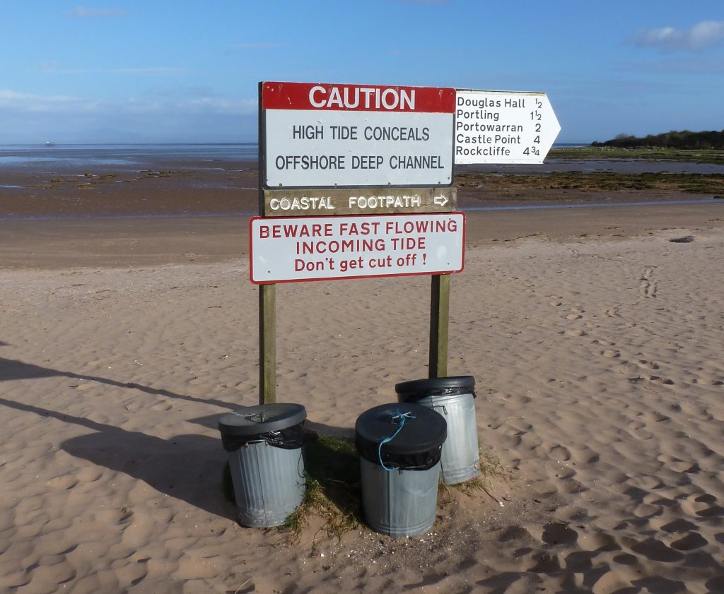
Image; Tidal sign. © N. Coombey/ Solway Firth Partnership.

Water circulation

Tides

The Solway Firth is a macromareal (a tidal range greater than 4m) and has two tide cycles per day, otherwise known as semidiurnal tides. Tides have many features such as an ebb and flow (discussed below) and spring and neap tides, which create tidal variability from the Earth and moon orbits. Spring tides, which are much greater than neap tides, refer to the tides which occur during a new or full moon. This means the sun and moon are working together to give a greater gravitational pull and larger tides. Conversely, neap tides occur when the gravitational pull off the sun partially cancels the pull of the moon. For example, spring tide measured at Hestan Islet gives a 7.24m range, whereas the neap tide in the same location gives a 3.80m range (Neill et al, 2017).

The mean spring tidal range in the Solway exceeds 7m, compared to an average of 3-4m for Scotland. According to Allerdale Borough Council (2011) this spring range is increased to roughly 8.4m at the boundary between the inner and outer Solway, as a result of the funnel shape of the inner Solway.

The Solway has the second greatest tidal range in the UK, after the Severn Estuary (15m). The UK has the second greatest tidal range in the World, after the Bay of Fundy in Canada (16.3m). However, the tidal range does vary in different areas of the Solway.

At Stranraer the range between mean high water and mean low water of spring tides is approximately 2.8m; at Kirkcudbright it is 6.7m; at Silloth it is 8.4m; and at Redkirk near the head of the estuary, the spring range is 3.6m (Cutts and Hemingway, 1996). Upstream of Glasson on the Bowness headland the estuary dries out completely at low water during spring tides, leaving only freshwater flowing in the channels.

The narrowing of the estuary has a funnelling effect and raises the local mean sea level at Redkirk by several metres above the mean sea level at Silloth (Black et al., 1994). Under normal conditions high tide at Annan occurs about one hour after high tide at Maryport.

Adding to this variability, the high tide at Kirkcudbright can occur over 2 hours before it does at Redkirk (Cutts and Hemingway, 1996).

All tides also feature an ‘ebb‘ and ‘flow‘/’flood‘. The ‘ebb‘ being the tide going out, and the ‘flow‘ referring to the tide returning and progressing towards high tide, flooding in towards the land. This  tidal feature also has variability in different parts of the Solway relating to the time taken for the ebb and flow. Up to Hestan Island the flow and ebb tide take roughly the same length of time. This is unlike at Redkirk near the head of the Firth where, during spring tides, the ebb lasts approximately six hours, followed by a five-hour slack period at low water. The flow tide then rises over 4m in two hours (Black et al., 1994).

For coastline tidal ranges and levels, and estimated extreme tidal levels, please see the Dumfries and Galloway Shoreline Management Plan (HR Wallingford Limited, 2005) Tables 2.2 and 2.3. The discussion of tidal levels within this Plan is focussed primarily on the Dumfries and Galloway coastline but also provides some cross-border elements.

Tidal gauges are installed at Kirkcudbright Bay, and there is a monitoring station to measure the tidal level at Workington.


Of course, given the long standing folklore which surrounds the Solway it may be unsurprising that the tides have not escaped from folklore stories. The nine tides, a phenomenon seen from the Mull of Galloway where opposing, conflicting, tidal rips twirl, this occurs 90 minutes after low tide. However, traditional folklore of the nine tides has a different explanation for this occurrence. A spell cast by nine witches to entrap sailors passing by the Mull of Galloway was never lifted and continues to this day.


Image; Scotland’s National Marine Plan Interactive, with layers (links will provide usage licence, data provider, etc); ‘Solway Region (mask) © Crown Copyright, All rights reserved, and ‘Mean Spring Tidal Range (m)‘ © Crown Copyright. All rights reserved

Water circulation

Tidal bore

As mentioned above, the tide of the Solway often flows back in faster than the slow progression of the ebb tide. These ebb and flow tides also travel in different patterns, as well as at different speeds, moving the sand in the estuary and shifting the Solway’s sandbanks.

As a result of the speed of these tides there sometimes occurs a rare phenomenon called a tidal bore. A tidal bore is when the flow phase of the tide creates a wave as the water rushes back up rivers through small outlets, while pushing back against the current of a shallow river. Tidal bores are known to occur on the River Nith between the village of Glencaple and the river mouth into the Solway. According to a 1991 study (ABP Research and Consultancy, 1991) a tidal bore can also form at Annan Waterfront. It can travel up to 11 kilometres per hour in speed and a height of 1.5 meters. However, this height can be raised even further under the correct high wind and low atmospheric pressure conditions. The tidal bore begins while the tide is still moving inwards, roughly 2 hours prior to the high-water level, which is reached after the bore has dissipated. Tidal bores are also known to occur from the Solway Firth into the River Eden in Cumbria, which can reach around 1 metre in height. In October 2020 large tides saw tidal bores occur on the River Whampool and River Eden in Cumbria. Several videos of the tidal bore event were uploaded to Twitter under the tag; ‘#solwaybore‘.


Video; Tidal Bore at Glencaple © E. Baruah/ Solway Firth Partnership

Water circulation

Tide and wave induced currents

The rise and fall of tides create tidal currents in estuaries and can also influence the transport of seabed sediments. In the Solway the general pattern of water movement near the surface is thought to be seawards, whilst the near-bed currents pass upstream leading to a long-term build-up of sediments at the head of the Firth.

As already discussed, the Solway features a large tidal range which results in strong tidal currents, with a spring tide maximum speed of 4 knots, and 2 knots during neap tides (Cuts and Hemingway, 1996). Although, the tidal currents are variable throughout the Firth and an assessment of the tidal currents throughout the Scottish side of the Solway is available through the Dumfries and Galloway Shoreline Management Plan (2005).

Wind conditions can also significantly impact sediment transport. It is, therefore, likely that a substantial quantity of sediment is transported into the estuary from the Irish Sea as a result of westerly and south westerly winds. The relative strength and duration of the tidal ebb and flood velocities tend to produce a resultant upstream transport vector which is augmented by wave induced currents operating in a north-easterly direction. The patterns of water movements in the shallow inshore areas of the Solway are complicated by the changing depth or bars, banks, low water channels and river flows.


Image; Scotland’s National Marine Plan Interactivewith layers (links will provide usage licence, data provider, etc); ‘Solway Region (mask)© Crown Copyright, All rights reserved, and ‘Annual Mean Significant Wave Height (m)‘ © Crown Copyright. All rights reserved

Water circulation

Waves

Natural waves are created as wind blows over an open area of water. Although it is worth noting that waves can also be created through unnatural means. Generated waves are created through the movement of the vessel and the size of wave created depends largely on the size and speed of the ship. Unnatural waves created as a result of large ferries in Cairnryan were noted as an ongoing concern in the 2005 Shoreline Management Plan for Dumfries and Galloway, despite speed restrictions being in place to limit waves.

Natural waves are generally larger in more open spaces as a result of wind building up bigger waves. This length of open water is called the fetch length. The Solway is somewhat protected from strong gales and large fetch lengths due to its location. It is protected by the Mull of Galloway, the western side of which is exposed to larger waves from the Irish Sea, and Northern Ireland from strong north westerly and Atlantic winds. The Firth also benefits from the Isle of Man, located to the south-west limiting fetch length. This shelter along with shallow offshore conditions beyond the mouth of the Firth means that wave action is reduced. The Solway is mainly effected by localised waves generated from the Irish Sea, being altered by the wind speed, strength and direction.

Wave conditions in the outer estuary are predominantly generated by wind fields blowing across the Irish Sea, usually from the northwest in the winter and southwest in the summer. However, the coast of both sides of the Solway are exposed to different fetch lengths dependant on the wind direction. The 2005 Dumfries and Galloway Shoreline Management Plan discusses the funnelling of north-westerly winds into the Firth. Furthermore discussing that the predominant wind direction (southwest) is in line with where the Firth is left open to waves, and as such the Firth is ‘exposed to onshore wave conditions for a high percentage of the time’ (HR Wallingford Limited, 2005). Cutts and Hemingway (1996) reported that a deployed wave rider recorded waves up to a maximum of 3.9m in the outer Solway, with the largest waves being experienced in winter.

Wave size is generally correlated with the strength of the westerly winds. The northern shores of the inner Firth (east of the Nith) are most prone to wave action generated within the estuary.

Other Solway Firth factors limit the development of waves, such as the inter-tidal flats and sandbanks. Wave height is, on average, less 1m within the inner Solway with the waves in the Solway landward of Workington and Abbey Head being highly sensitive to water level (HR Wallingford, 2005).

Areas of bays and inlets along the coastline have reduced wave power than exposed areas of the coastline. Wave power dissipates in bays and inlets for a variety of reasons, such as the surrounding land reducing wind and changing the direction of waves, reducing their power. They often feature shallower water and have reduced space, also restricting wave energy and fetch lengths. Bays and inlets are more common on the Dumfries and Galloway side of the Solway, and of a more significant size, than on the Cumbrian side. The shelter provided by bays and inlets for the Scottish side of the Firth is presented in the National Marine Plan Interactive data layer ‘Wave Exposure Index (Wave Fetch Model)‘.


Image; Fetch lengths of waves in the Solway Firth. © Solway Firth Partnership (1996)

Water circulation

Water temperature

The Solway benefits from the North Atlantic Drift (northern extension of the Gulf Stream) which helps produce warmer temperatures in the Firth. This is also assisted by the shallow nature of the Firth, especially in the inner Firth. Concern is growing, however, that the impacts of climate change will continue to weaken the Gulf Stream, which is already 15% weaker than it was 50 years ago (The Scotsman, 2020).

Sea temperatures are rising (See Climate Changes – Sea Level rise and coastal flooding) and the temperature of the Solway is also predicted to rise in the future. In 1996, NatureScot reported that temperatures in the inner Solway varied, depending on the time of year and with temperature changes occurring more dramatically in the inner Solway. Between 5°C in the winter and over 15°C in the summer for sea surface temperature and range between 5°C and 12°C for bottom temperatures (Cutts and Hemingway, 1996). In the deeper, less enclosed Solway these temperatures have less variation. As global warming continues to heat up the Solway, these averages will rise. The medium emissions projections from the UK Climate Projections 2009, for example, suggest that the winter increase in sea surface temperature by 2085 (compared to 1975) in the Solway will rise between 2.5°C and 2.6°C. There has since been an update to the 2009 climate projections, however, this data was provided in the data layer for the National Marine Plan Interactive based on the 2009 projections (Marine Scotland, 2017).


Image; Scotland’s National Marine Plan Interactive, with layers (links will provide usage licence, data provider, etc); ‘Solway Region (mask)© Crown Copyright, All rights reserved, and ‘Annual Mean Near-bed Temperature (°C) – Climatology of the North-West European Continental Shelf for 1971–2000© Crown Copyright, All rights reserved.

Water circulation

Salinity

The salinity of the Solway depends on a number of factors including distance downstream, the time of year, and freshwater input from rivers. During high freshwater input the inner area of the Firth has salinities of 16-22 ppt*, which rise to 31-32 ppt* at low freshwater input (Cutts and Hemingway, 1996).

A salinity gradient (rate where freshwater becomes more saline) will depend on the level of mixing between freshwater and saltwater within a water body. In the case of the inner Solway, intense mixing means that there is not a gradient. Alternatively, where the flood tide meets freshwater where it enters the Solway, there is a strong gradient of salinity. Not only does the strong salinity gradient effect the biodiversity of the area, but it also increases sediment deposition in the nearshore environment through flocculation. 

*ppt stands for parts of salt per thousand parts water.


Image; Scotland’s National Marine Plan Interactive, with layers (links will provide usage licence, data provider, etc); ‘Solway Region (mask)© Crown Copyright, All rights reserved, and ‘Annual Mean Surface Salinity (‰) – Climatology of the North-West European Continental Shelf for 1971–2000© Crown Copyright, All rights reserved.

Water circulation

Suspended particulate inorganic matter (turbidity)

Particulate matter suspended in the water column is a key consideration to the clarity of seawater. Suspended particular matter (SPM) are the floating particles which are suspended in the water column such as plankton, sand and mineral particles. SPM may be mobilised by natural means such as waves, human activities such as construction or dredging, or may be input into the water column through outfalls or run-off. SPM may positively impact primary producers through increasing nutrient concentrations, however can reduce light availability and therefore reduce photosynthesis productivity (Moffat et al, 2020). Scotland’s Marine Assessment measured inorganic SPM ‘by ocean colour satellites from space…to summarise the turbidity in Scottish waters’. (Moffat, et al, 2020).

Inshore regions generally feature much higher suspended particulate inorganic matter (SPIM) concentrations than offshore areas due to inputs from coastal sources, activities, and wave action etc. Based on the assessment, ‘the Solway Firth has by far the highest SPIM concentrations, on average between 4 and 6 mg/l but greater than 20 mg/l during isolated events (potentially linked to high river run off). The high SPIM concentrations in the Solway can last for several months at a time’ (Moffat et al, 2020).

The satellite data (‘SPIM concentrations (mg/l) in Scottish waters, climatological average 1998 – 2015’) shows consistency between the Scottish and English sides of the Firth. Almost the entire English Solway has the same high average SPIM (5mg/l) as the majority of the Scottish Solway.  The finding above refers to the Solway as a whole ‘the Solway Firth’ as opposed to the Solway Marine Region which covers only the Scottish side of the Firth.


Image; Knockbrex, Bathing House Bay. © Solway Firth Partnership

Water circulation

Depth

In the inner Solway is very shallow, often not exceeding 10m depth, and maximum depths off around 20m and with large intertidal sandbanks visible at low tide. The tidal range means that water depth is highly variable dependant on the tide. This depth complexity is compounded by the sandbanks which change the depths of the inner Solway on a daily basis. Navigation of the shifting sandbanks, rocky scars, boulders, and changeable depths is complex. As such, any vessel >50m is required to have a pilot on board before passing the Port of Workington to travel to Silloth harbour.

The outer Solway has depths greater than in the Inner Solway, gradually deepening as the Firth transitions out to the Irish Sea. Depths descend in a much steeper gradient off the coast of the Rhins of Galloway, where Beaufort’s Dyke, a previous munitions dump, is located.


Image; Walkers on the coast © Solway Firth Partnership. Photographer; K. Kirk

Water circulation

References

Baxter, J.M., Boyd, I.L., Cox, M., Donald, A.E., Malcolm, S.J., Miles, H., Miller, B., Moffat, C.F., (Editors), (2011). Scotland’s Marine Atlas: Information for the national marine plan. Marine Scotland, Edinburgh. pp 191. Available here. (Accessed: 22.07.19)

Marine Management Organisation. (n.d.). Marine Planning Evidence Base. Available here. (Accessed: 14.05.18)

Marine Scotland (n.d.). Scotland’s National Marine Plan Interactive. Available here. (Accessed: 06.08.19)

Mills, F., Sheridan, S. and Brown S., (2017). Clyde Marine Region Assessment. Clyde Marine Planning Partnership. pp 231. Available here. (Accessed: 14.05.18)


In-Text References;

ABP Research and Consultancy Ltd. (1991). Silloth Coastal Study. Commissioned by Associated British Ports, Barrow and Silloth.

Allerdale Borough Council. (2011). Annual Local Monitoring Report. Coastal Engineering UK Ltd. Available here. (Accessed: 05.08.19)

Black, D., Hansom, J. D., & Comber, D. P. M. (1994). Estuaries Management Plans-Coastal Processes and Conservation: Solway Firth. (Not Accessible, credited through other sources used)

Cutts, N., and Hemingway, K. (1996). The Solway Firth: broad scale habitat mapping. NatureScot Research. Survey and monitoring report. No 46. Available here. (Accessed: 05. 08.19)

Department for Environment, Food and Rural Affairs (2019). Marine strategy part one: UK updated assessment and Good Environmental Status. Available here. (Accessed: 02.02.21)

HR Wallingford Limited. (2005). Dumfries and Galloway Shoreline Management Plan Study: Stage 1, Volume 1, Report EX 4963 Rev 2.0. Available here. (Accessed: 05.08.19)

Marine Scotland (2017). Scotland’s National Marine Plan Interactive, ‘UKCP09 Projections – Increase in sea surface temperature (ºC) by 2085, compared to 1975, medium emissions scenario – winter’. Available here (Accessed: 21.06.19)

Moffat, C., Baxter, J., Berx, B., Bosley, K., Boulcott, P., Cox, M., Cruickshank, L., Gillham, K., Haynes, V., Roberts, A., Vaughan, D., & Webster, L. (Eds.). (2020). Scotland’s Marine Assessment 2020. Scottish Government. Available here. (Accessed: 10.04.21)

Neill, S. P., Vögler, A., Goward-Brown, A. J., Baston, S., Lewis, M. J., Gillibrand, P. A., Waldman, S., & Woolf, D. K. (2017). The wave and tidal resource of Scotland. Renewable energy, 114, 3-17. Available here. (Accessed: 05.08.19)

Solway Firth Partnership (1996). The Solway Firth Review, Solway Firth Partnership, Dumfries. Available here. (Accessed: 23.07.19)

The Scotsman (2020). How the ocean current that keeps Scotland warm could collapse – Dr Richard Dixon. Available here. (Accessed: 18.06.20)


Image; Waves at Workington. © Solway Firth Partnership