Defence

Defence covers activities which are part of the UK’s military activities to protect and defend the UK. This can cover a range of activities over land, sea, and air. There is a range of defence activities in the Scottish Solway, with the Socio-economic Assessment of the English Solway unable to identify any socio-economic contribution of defence activities to the English side of the Solway Firth. Defence is a matter reserved with the UK government and has a common, UK wide, approach.

As mentioned in the overview for the Productive chapter introduction of the Solway Review, this section is populated with data and information from the Socio-economic Assessment’s for the Scottish (SEASS), and English Solway (SEAES), which are two separate projects completed in 2020. Text below will be predominantly directly from the SEASS or SEAES Reports but is altered at times. These reports are available here. These socio-economic reports were needed in light of the changing face of socio-economic aspects impacting the Solway Firth, and also for the purpose of populating the productive section of the Solway Review. Text from the SEASS and SEAES reports is not referenced individually.


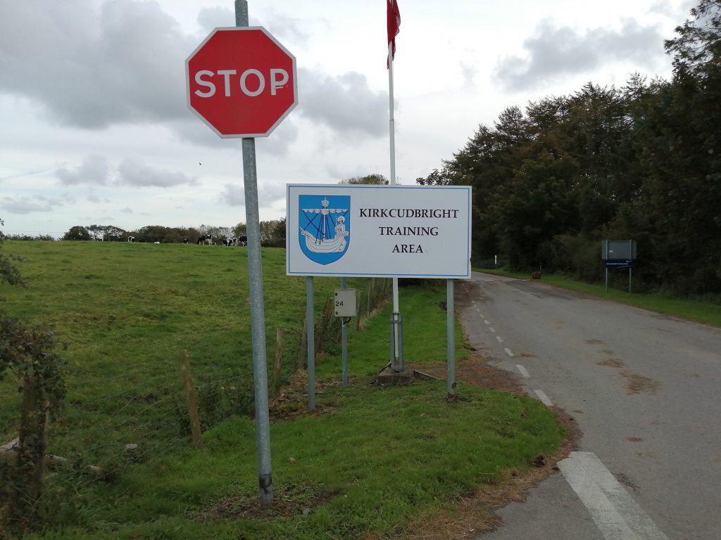
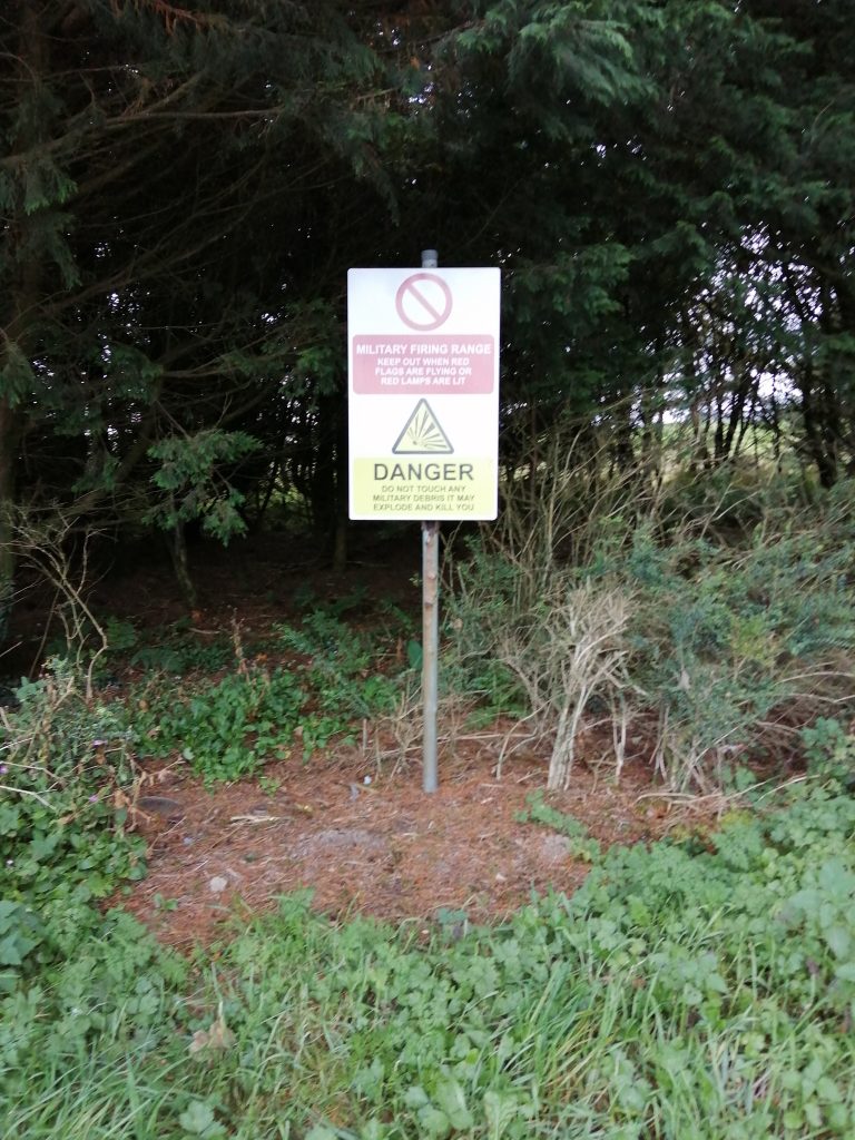
There is a limited level of defence activity and employment related to the Scottish Solway coast. The main sites are Ministry of Defence (MOD) West Freugh weapons test and evaluation range on Luce Bay, and the Kirkcudbright Training Area.

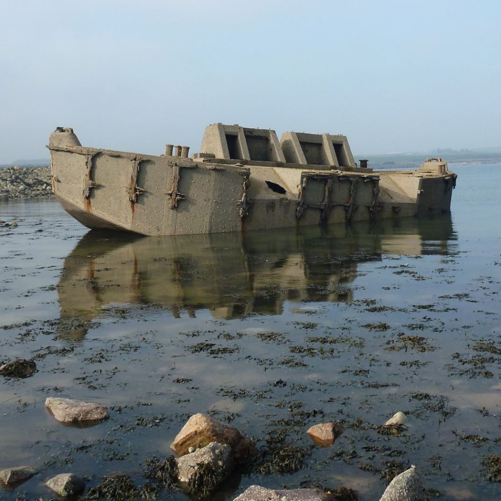
Around the Scottish side of the Solway the historic connection to extensive military activity can be seen. An example of previous defence activity is the platform at Sandyhills which was an RAF bombing target used by the World War II (WWII) Heathall airfield. Garlieston also has an important connection to WWII, it was where Mulberry Harbour prototypes were tested prior to D-day landings. Several Beetle potoons now lie on coastal rocks, with a well preserved example at Cairnhead Bay, Portyerrock (pictured below). Previous defence activity in and around the Solway contributes to the cultural heritage and draws visitors to the area through tourism. Garlieston has had exhibitions and books focussed on this point in Garlieston’s history, and even holds a military themed weekend calledGarlieston’s Military Weekend each year with a vintage 1940’s theme to celebrate and remember the historic connection Garlieston had to World War II.

Much of the physical evidence of WWII history around Loch Ryan has been dismantled and dispersed. However there are a few publicly accessible sites that still show structures from that period such as the lookout post and flying boat slip ways at the Wig.  The Loch Ryan WWII leaflet below provides more information of sites to visit.

The English side of the Solway has also seen its fair share of past military activity, with Drumburgh WWII bombing range, which continues to feature a large white target guide arrow marked on Easton marsh (Latitude 54.927212, Longitude -3.130580). Many buildings survive from the previous RAF Silloth, former Royal Air Force station one mile north-east of Silloth. Blitterlees Bank was also a testing site for weapons during World War I. Opened by Armstrong’s, the live firing of new weapons systems allowed the recovery of empty shells at low tide, and more privacy due to the ‘remote’ location. The BBC has an audio clip (available here) discussing this important time in Blitterlees’ history in the collection of clips focussed on ‘World War One at Home’.

See Historic Environment and Cultural Heritage for some more information on the military history around the Solway Firth.


Defining the Sector

The defence sector is defined as the Standard Industrial Classification (SIC) code (Office for National Statistics, 2007): 84.22: Defence activities. MOD West Freugh is classified under the Standard Industrial Classification (SIC) code (Office for National Statistics, 2007): 72.19: Other research and experimental development on natural sciences and engineering.


Between 2014 and 2018 the employment in the defence sector reduced by 11%.

Change in Activity, 2014 – 2018

Indicator

Change

Employment

-11%


Image; Beetle Pontoon at Cairnhead Bay, Portyerrock, near Garlieston © N. Coombey/ Solway Firth Partnership.

Defence

Contribution to the Economy

Defence employment has remained broadly steady at around 40 to 50 since 2011 in Dumfries & Galloway. There was a fall in employment of around -40% from 2010 due to the mothballing of Eastriggs Weapons storage depot, see figure below, ‘Solway Defence Employment 2009-2018’.

It should be noted that this only includes full-time permanently located staff and that Kirkcudbright training area is in regular use by military personnel which are not included in these figures.


Scottish Solway Defence Employment 2009-2018

Scottish Solway Defence Employment 2009-2018 (Source: Office for National Statistics (Various) (BRES))


The Location Quotient (please see the Productive overview for an explanation of Location Quotients) of the defence industry has fluctuated over time, but defence employment is consistently much less concentrated in Dumfries & Galloway than in Scotland as a whole, see figure below, ‘Scottish Solway Defence Employment Location Quotient 2009 – 2018’.


Scottish Solway Defence Employment Location Quotient 2009-2018

Scottish Solway Defence Employment Location Quotient 2009-2018 (Source: Office for National Statistics (Various) (BRES))


Economic Output – Turnover and GVA

Turnover and GVA data are unavailable for the defence sector and are not collected by either the Annual Business Survey or the Scottish Annual Business Statistics.


Image; Kirkcudbright Training Area © Solway Firth Partnership.

Defence

Solway Defence Activity

All Ministry of Defence byelaws for Dumfries and Galloway are available here.

Beauforts Dyke Explosives Disposal Site

Beauforts Dyke is a sub-sea trench 50km long, 3.5km and over 300m deep off the Rhins of Galloway which has been used as a disposal ground (see map opposite) for conventional weapons, chemical weapons, and nuclear waste since at least the end of the Second World War, and potentially as early as 1920.

After incidents of munitions washing on shore in 1995 due to the laying of a sub-sea gas pipeline, a survey was undertaken which discovered that large quantities of munitions had been dumped outside of the dyke. However, analysis concluded that this dumping had not contaminated fish/shellfish (commercially exploited) nor seabed sediments (Fisheries Research Services (n.d.)). Please see Fishery Research Service’s Case Study for more information. The full report on ‘Surveys of the Beauforts Dyke Explosives Disposal Site’ can be found here.


Ministry Of Defence (MOD) West Freugh

MOD West Freugh is a weapons test and evaluation range located at the Northern end of Luce Bay, approximately 10km south of Stranraer with 750 km2of airspace, 380 km2  sea area and 12 kmof land available for military training, exercises and testing. The site is currently operated by QinetiQ on behalf of the MOD.

Whilst the runways at the site are disused, they are available for military training, exercises and testing.


Kirkcudbright Training Area

Kirkcudbright Training Area is an area of approximately 19 kmto the south of Kirkcudbright used by the MOD for live fire training exercises with an approximate 750 kmsea danger area. It is in regular use by the MOD with the area frequently closed to walkers and military jets often heard in the area.

Dundrennan range is a military testing range located in the Kirkcudbright Training Area. It was previously the site of the Electro-Magnetic Launch Facility (UK Defence Journal, 2017) (or railgun). The MOD will be test firing armoured vehicle rounds over the next five years at the site, which has led to increased restrictions on access (Daily Record, 2019). There are plans to further develop the site, however these were described as in “the very early stages of development” in 2018 (UK Parliament, 2018).


Eastriggs Weapons Storage Depot

Eastriggs Weapons Depot is a former Explosives Storage Depot which was mothballed in 2011. It formed part of a complex of major munitions storage and manufacturing sites during the First and Second World Wars. There have been some suggestions of redeveloping it as a tourist attraction, however, it does not appear as if any progress has been made (Daily Record, 2013).


Image; Scotland’s National Marine Plan Interactive, with layers (links will provide usage licence, data provider, etc); ‘Solway Region (mask)‘ © Crown Copyright, All rights reserved, ‘Defence (Military) – Historic munitions disposal sites‘ © British Crown and OceanWise, YYYY. All rights reserved. License No. EK001 – 20140401. Not to be used for Navigation, ‘Defence (Military) – Military exercise areas and danger areas (PEXAs)‘ © British Crown and OceanWise, YYYY. All rights reserved. License No. EK001 – 20140401. Not to be used for Navigation, ‘Defence (Military) – MoD establishments and estates‘ © Crown Copyright, All Rights Reserved. Defence Infrastructure Organisation (Lic No 100023818). See terms of use for further limitations.

Defence

Pressures and Impacts

An assessment of the socio-economic and environmental pressures and impacts of the defence sector is provided below.

Socio-Economic
Positive Negative
•   Regional employer – supports a number of high skilled and high value jobs •   Competition for coastal locations and routes – with fishing and other marine activity restricted close to MOD sites
Environmental
Pressure theme Pressure Impact
Pollution Introduction of hazardous substances There is a risk of contamination due to spillages from the discharge of fuel, munitions or other contaminants including radionuclide contamination. There has been particular concern about the testing of Depleted uranium munitions at Dundrennan range, however, this was ceased in 2008 (BBC News, 2013).
Other physical Litter: discarded munitions and explosives There are (historical and current) munitions dumping sites in the area surrounding Beaufort’s Dyke between Scotland and Northern Ireland.

Despite this, there is little evidence that shows the impact of pollution on either the seabed or marine wildlife (Fisheries Research Services, n.d.).

Aircraft noise No specific studies have been undertaken of the impact on the noise disturbance of MoD sites on the Solway. There is some concern that noise from low-flying aircraft in particular may have some impact on wildlife.
Habitat change Habitat damage There is some evidence of environmental benefits in military training areas, as they are subject to heavy land use restrictions and there is limited development on these sites outside of military requirements.

Defence

Regional Look Forward

There are no major changes proposed on the Scottish Solway Coast in the coming years in terms of defence. There are planned upgrades at Kirkcudbright Training Area, signalling the MOD’s commitment to maintaining it as a testing and training facility. There have been some indications that the former Eastriggs Weapons Storage Depot could be redeveloped, potentially as a tourist attraction, however, little progress has been made to date. Historical military and defence activities form a tourism draw to the Solway, with guides such as the Solway Military Trail, and Loch Ryan, the secret WWII flying boat base helping to spread awareness of the rich military history around the Solway.


Image; Warning Sign around the Kirkcudbright training area © Solway Firth Partnership.

Defence

References

Baxter, J.M., Boyd, I.L., Cox, M., Donald, A.E., Malcolm, S.J., Miles, H., Miller, B., Moffat, C.F., (Editors), (2011). Scotland’s Marine Atlas: Information for the national marine plan. Marine Scotland, Edinburgh. pp 191. Available here. (Accessed: 22.07.19)

Fisheries Research Services (1996) Fisheries Research Services Report No 15/96. Surveys of the Beauforts Dyke Explosives Disposal Site. Available here. (Accessed: 21.08.20)

Marine Management Organisation. (n.d). Marine Planning Evidence Base. Available here. (Accessed: 14.05.18)

Marine Scotland (n.d.). Scotland’s National Marine Plan Interactive. Available here. (Accessed: 06.08.19)

Mills, F., Sheridan, S. and Brown S., (2017). Clyde Marine Region Assessment. Clyde Marine Planning Partnership. pp 231, Available here. (Accessed: 14.05.18)

Office for National Statistics (Various) Annual Business Survey (ABS): custom data request from the ONS & Public data. Available here. (Accessed: 28.07.20)

Scottish Government (2019) Scottish Annual Business Statistics 2017 (SABS). Available here. (Accessed: 28.07.20)


In-Text References:

BBC News (2013) Dundrennan depleted uranium protest staged. Available here. (Accessed: 17.07.20)

Daily Record. (2019) Dundrennan villagers demand answers from Ministry of Defence over restricted access at military range. Available here. (Accessed:16.07.20)

Daily Record. (2013) Moth-balled MOD depot is vision for tourism attraction. Available here. (Accessed: 17.07.20)

Fisheries Research Services (n.d.) Munitions Dumping at Beaufort’s Dyke. Available here. (Accessed: 27.07.20)

Office for National Statistics (Various) Business Register and Employment Survey (BRES). Available here. (Accessed: 28.07.20)

Office for National Statistics (2007). Standard Industrial Classification of Economic Activities. Available here. (Accessed: 22.07.20)

UK Defence Journal (2017) Electro-Magnetic Rail Gun in action. Available here. (Accessed: 17.07.20)

UK Parliament. (2018) Hansard, Firing Ranges: Dundrennan: Written question – 130819. Available here. (Accessed 16.07.20)


Image; Tree on the bank of the Nith.  © G. Reid/ Solway Firth Partnership.