Subtidal rock

Status of subtidal rock: Stable with few/no concerns

(Baxter et al, 2011)

Status for benthic habitats: Stable situation since 2012

(United Kingdom Marine Monitoring & Assessment Strategy, n.d)

Subtidal refers to the marine area below the low water mark, meaning that it is constantly underwater. Unlike the intertidal zone (see intertidal rock, sediments and biodiversity) this means that species are not exposed to the atmosphere and don’t dry out in the sun or get exposed to the cold air of the winter. However, as water deepens in the subtidal area light dissipates, impacting the species which can survive in this habitat. Light becomes scarce below 50m with water below the photic zone (up to 200m deep) being without sunlight. The photic zone has sufficient sunlight to allow photosynthesis, however this capacity reduces with depth, therefore shallow areas are most abundant with seaweeds, which dwindle as depth increases, and cannot survive below the photic zone. Below this zone communities are comprised exclusively of animals. The Solway Firth is relatively shallow throughout with depths rarely exceeding 50m, with the most notable exception of Beaufort’s Dyke.

Subtidal rock can include bedrock, boulders or cobbles. The Solway has subtidal rock in the outer firth, with the majority of the Firth being characteristic of other inshore environments around the UK, being predominantly soft sediment. Subtidal rock exposures occur along the north coast of the Solway between Auchencairn Bay and the Mull of Galloway. They also occur along the west coast of the Rhins. Scottish subtidal rock can be explored in the National Marine Plan Interactive, with the specific data layer on subtidal rock available here. The Cumbrian side of the Firth is almost entirely sedimentary and lacks extensive subtidal rock. The composition of the benthic communities is strongly influenced by the strength of the tidal streams and the turbidity of the water. To the west of the Isle of Whithorn communities are richer and dominated by tunicates and sponges, to the east erect bryozoans and hydroids dominate. East of Burrow Head rocky seabed is restricted to a narrow, shallow fringe around the coast. According to the Dumfries and Galloway Local Biodiversity Action Plan (DGLBAP) ‘the rocky seabed to the west of the Isle of Whithorn has the greatest biodiversity’ (Dumfries and Galloway Biodiversity Partnership, 2009). Subtidal bedrock is of extremely limited extent in the inner Solway. The most diverse communities are recorded at Burrow Head and further west, on the Mull of Galloway and the Scares.


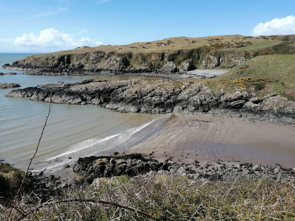
Image; Killantringan and Knock Bay. © G. Reid/ Solway Firth Partnership

Subtidal rock

Solway Subtidal Rock

Hard seabed is more extensive to the west, particularly around the Mull of Galloway and the Scares, where it extends from the subtidal fringe to around 20m depth. This, combined with reduced turbidity, allows the development of richer and more diverse communities. Kelp occurs on subtidal bedrock but reduces in abundance as depth increases. According to the DGLBAP kelp ‘thins out with increasing depth and red algae dominate. Rhodochorton purpureum is a common species of crevices. Drachiella heterocarpa, a small red seaweed confined to the subtidal zone of wave-exposed coasts, particularly subtidal cliffs, has an extremely limited western distribution in Britain with few Scottish records. It occurs at Burrow Head. On rock surfaces in deep water seaweed may be absent altogether.’ (Dumfries and Galloway Biodiversity Partnership, 2009).

At shallower depths the bedrock is dominated by a forest of kelp (Laminaria hyperboreawith foliose red algae being common. Kelp stipes (stems or stalks) themselves support a rich plant life of mainly Cryptopleura ramosa, Phycodrys rubens and Palmaria palmata, which in turn are colonised by the bryozoans (Electra pilosa and Alcyonidium hirsutum). The algal cover under the kelp is quite dense but not particularly diverse. The anemone Actinothoe sphyrodeta is common. With increasing depth, the kelp forest thins out, with an open kelp park extending down to a depth 7-10m and red foliose algae dominating. Kelp forests are found at Lady Bay in Loch Ryan and the Mull of Galloway. Typical species include oarweed (Laminaria digitata) sugar kelp (Saccharina latissima) and dabberlocks (Alaria esculenta). Smaller red seaweeds amongst the kelp include the bootlace weed (Chorda filum) at Drummore Bay, Rhodochorton purpureum (crevices) and Drachiella heterocarpa (wave-exposed) (Dumfries and Galloway Biodiversity Partnership, 2009).

Where there is insufficient light for plants to grow, rock is dominated by sponges, hydroids and ascidians. The sponge Amphilectus fucorum covers up to 30% of the rock surface in places. The first Scottish record of an undescribed ascidian was found in this community at the Mull of Galloway. Similar communities are likely to be present off the Scares. Bedrock here is dominated by low-lying colonial ascidians, the hydroid Tubularia indivisa and the elephant’s ear sponge (Pachymatisma johnstonia).

Important subtidal rock communities include regions around the Mull of Galloway, Scare Rocks (20m) and the mouth of Loch Ryan. According to the DGLBAP the deepest area of subtidal rock is Beaufort’s Dyke in the North Channel (302m, 50km long and 3.5km wide).

Hard seabed within Luce Bay is shallow and generally consists of a mixture of bedrock, boulders, cobbles and pebbles, mobile or sand-scoured to varying extent. These habitats are dominated by red and brown algae with sugar kelp, (Laminaria saccharinabeing the most conspicuous species. Dead man’s rope is a bootlace weed (Chorda filum) which occurs in Drummore Bay, within the shelter of the Mull of Galloway but is lacking from the eastern side of Luce Bay, presumably due to the increased wave exposure.

At Burrow Head the bedrock and boulder habitats are current-swept and dominated by ascidians and the reef-building polychaete Sabellaria spinulosa. Most of the lower plant-dominated zone is rich in foliose red algae and ascidians, with dense stands of the bryozoansFlustra foliacea and Bugula plumosa, and populations of the feather star (Antedon bifida). The ‘tube-building’ Ross/reef worm (Sabellaria spinulosa) increases in abundance with depth. Burrow Head supports particularly rich communities and is of special interest.

To the east of Burrow Head, hard seabed is limited to a very shallow fringe around the coast, with the exception of artificial surfaces such as the wreck of the ‘Jasper’ in Wigtown Bay. The community on the wreck is similar to that found on shallow bedrock east of Burrow Head but species such as the plumose anemone (Metridium senile) and the large solitary ascidians (Ascidia mentula and Ascidiella aspersa) are more common due to the more sheltered conditions in deeper water. Several fish species occur on the wreck, including pollack, bib, goldsinny wrasse and conger eels.

The seabed in subtidal ‘scar’ grounds (exposed boulder clay) which remains clear of sand supports a rich and well-developed fauna typical of subtidal rocky areas. It also includes sponges, soft corals, bryozoans including Flustra foliacea, tunicates such as the red sea squirt (Dendrodoa grossularia) hydroids, and the honeycomb ‘reef-building’ worm (Sabellaria alveolata). This community occurs extensively off Maryport and Allonby Bay. It shows some similarities with the rocky subtidal communities recorded east of the Isle of Whithorn. The honeycomb worm is far more common in the intertidal zone (see Intertidal rock, sediments and biodiversity) than in subtidal areas.

The seabed off the coast of Cumbria is almost entirely sedimentary in nature being made up of sand, sandy mud, gravels, with a few areas of boulder scars (exposed boulder clay). The lower part of the intertidal area around Dubmill is known for its many scars, including Dubmill Scar, Catherinehole Scar, Lowhagstock Scar, Lee Scar, Beck Scar and Stinking Crag. The inner Solway is predominantly sand whereas west of ~Maryport the seabed sediments turn to sandy mud or muddy sand. Sandy gravel and gravel seabed occurs offshore around Allonby Bay and Maryport. The extensive examples of rocky scars on the Cumbria coast support marine communities of nature conservation and commercial fisheries interest. 

Previous reports, including the original Solway Review and Cutts and Hemmingway (1996), reported horse mussel beds, (Modiolus modiolus), on ‘scar’ grounds in the Solway. It is unclear the extent to which beds remain in the Solway. Information available through sources such as the National Marine Plan Interactive (NatureScot, n.d.) and Annex I of Moffat et al (2011) suggest that horse mussel beds are no longer found in significant numbers in the Solway. Furthermore, the Marine Climate Change Impacts Partnership (MCCIP) published information on horse mussel beds (2018) including a map of OSPAR verified records of horse mussel beds throughout the UK. According to this MCCIP map there are no OSPAR verified records for horse mussel beds in the Solway. Conversely however, the Ocean Biodiversity Information System (n.d.) suggests there are still beds present around the Rhins and middle Cumbrian coast as well at St Bees Head. Areas beyond the Solway in the Irish Sea are known to have horse mussel bed habitat. The presence of horse mussels was mentioned in the Cumbrian subtidal habitat statement (Cumbria Biodiversity Data Centre, 2016), outlining that horse mussels can be found on boulder scars below the tidal zone in Cumbria. This highlights that there may be horse mussel beds in the Solway under boulder scars, however there is no clarity on whether these are intertidal or subtidal scars. The evidence base covers the entire Cumbrian coast so is not specific to the Solway. It is unclear the extent to which these occur on subtidal rock specifically in the Solway. However the DGLBAP suggests that small horse mussel beds are found along the Wigtownshire coast, and in Loch Ryan, Burrow Head (Dumfries and Galloway Biodiversity Partnership, 2009).


Image; Maidenhead Bay © G. Reid/ Solway Firth Partnership

Subtidal rock

Above subtidal rock

In open waters above subtidal rock many species can be found. Typical pelagic fishes include Atlantic herring (Clupea harengus) and mackerel (Scomber scombrus). Basking sharks (Cetorhinus maxima), harbour porpoises (Phocena phocena), common dolphins (Delphinus delphis), and bottlenose dolphins (Tursiops truncatus), are sometimes seen in the summer (Dumfries and Galloway Biodiversity Partnership, 2009).

Fish-eating birds are also associated with subtidal rock including gannets (Morus bassanus)guillemots (Uria aalga), and razorbills (Alca torda) (Dumfries and Galloway Biodiversity Partnership, 2009).

Crab species and the common lobster (Homarus gammarus) hide in rock crevices, feeding at night. The uncommon brown sea cucumber (Aslia lefevrei), and the daisy anemone (Cereus pedunculatus) have been found in Loch Ryan (Dumfries and Galloway Biodiversity Partnership, 2009).

Common rocky habitat fish species include: the tompot blenny (Parablennius gattorugine), conger eel (Conger conger), wolf fish (Anarhichas lupus), greater spotted dogfish (Scyliorhinus stellaris), cod (Gadus morhua), and haddock (Melanogrammus aeglefinus). Ballan wrasse (Labrus bergyltais), are found in shallower waters and young pollack (Pollachius pollachius), amidst seaweeds (Dumfries and Galloway Biodiversity Partnership, 2009).

As mentioned above, the Firth is characteristic of inshore environments around the UK, being predominantly soft sediment. This applies to both the Scottish and the English sides of the Firth.

The deeper water benthic habitats and communities support important fisheries; they provide feeding, nursery and fishing grounds for many species of fish and shellfish.


Image; Seaweed at Powillimount © G. Reid/ Solway Firth Partnership

Subtidal rock

Recent Trends

According to the DGLBAP subtidal rock and scar grounds are generally robust in the Solway Firth however, monitoring is limited. Climate change and dredging over reefs may have altered species composition (Dumfries and Galloway Biodiversity Partnership, 2009).

Communities which can be found living on subtidal habitats are indicators used for assessing benthic communities to measure progress towards achieving ‘Good Environmental Status’ (GEnvS). Achieving GEnvS in the marine environment is required as per the Marine Strategy Framework Directive to provide more effective marine environment protection and sustainable use. Subtidal rock is considered seabed habitat, and therefore are an indicator of the health of ‘benthic habitats’ for the purpose of measuring descriptors 1 (Biological Diversity) and 6 (Seafloor Integrity). For the purposes of assessing GEnvS for benthic habitats, indicators covering ‘rock and biogenic habitats, predominant sediment habitats, and intertidal habitats against targets’ (Department for Environment, Food, and Rural Affairs, 2019). GEnvS has not been achieved in the Celtic Seas for rock or biogenic habitats, with physical damage for rock, and physical loss for biogenic habitats inconsistent with GEnvS (Department for Environment, Food, and Rural Affairs, 2019). See the United Kingdom Marine Monitoring & Assessment Strategy, Marine Online Assessment Tool for more information on GEnvS, assessments and indicators.


Image; Waves at Workington © Solway Firth Partnership.

Subtidal rock

Priority habitats and pressures

Priority marine subtidal rock habitats;

Scottish Priority Marine Features (PMF) List available here.
UK Biodiversity Action Plan (UK BAP)* Habitat descriptions available here. Habitat descriptions for each specific priority habitat are available here.
Species and Habitats of Principal importance (SPI) England. List available here.
Features of Conservation Interest (FOCI) (Marine Conservation Zone Features) England. List available here.
Scottish Biodiversity List (SBL) Scotland. List available here.

*Note; The UK Biodiversity Action Plan has now been succeeded by the ‘UK Post-2010 Biodiversity Framework‘, published in July 2012. Despite this, the UK BAP lists of priority species and habitats are invaluable for Scotland and England when drawing up their own biodiversity lists.

Category Broad Feature
(see lists for
specific component
biotopes, subcategories
specific to subtidal rock)
Status Pressures/ Sensitivities  Presence
Biogenic reefs Blue mussel beds

(Mytilus edulis)

PMF/ SBL/ SPI/ FOCI/ UK BAP Anchoring, demersal fishing, coastal developments and pollution, storm damage, smothering Scotland,
England
Reef/ Ross worm

(Sabellaria spinulosa)

SPI/ FOCI/ UK BAP Dredging, trawling and fishing, pollution Scotland,
England
Honeycomb worm

(Sabellaria alveolata)

SBL/ SPI/ FOCI/ UK BAP Climate change, prolonged burial, change in sediment dynamics, development, competition for space with common mussels, variable recruitment, natural mobility, exploitation, coastal development, water abstraction, disturbance Scotland,
England
Horse mussel beds (Modilous modiolus) PMF/ SBL/ SPI/ FOCI/ UK BAP Physical damage to the seabed from mobile fishing gear which may severely damage or even destroy beds, activities which physically interact with the seafloor (such as drilling, development, aggregates), contamination (bioaccumulation) Scotland, England
Habitats  

Subtidal sands and gravels

SBL/ SPI/ FOCI/ UK BAP Pollution (sewage, discharges, spills), trawling, dredging, extractive activities, disturbance, development
Estuarine rocky habitats SBL/ SPI/ FOCI/ UK BAP Commercial fisheries, water quality, dredging, development, climate change, INNS Scotland,
England
Kelp beds

(Laminaria hyperborea)

PMF Seaweed harvesting, scallop dredging, any activity that reduces water flow, pollution Scotland
Tide swept algal
communities
PMF Seaweed harvesting, scallop dredging, any activity that reduces water flow, pollution Scotland


Tide-swept
channels
SBL/ SPI/ FOCI/ UK BAP Obstruction to water flow, tidal power generation, fishing, water pollution Scotland,
England

Subtidal rock

References

Cumbria Biodiversity Data Centre (n.d.). Available here. (Accessed: 10.03.18)

Cumbria Biodiversity Partnership (2001). The Cumbria Biodiversity Action Plan. Available here. (Accessed: 01.04.21)

Joint Nature Conservation Committee and the Department of Environment, Food and Rural Affairs (on behalf of the Four Countries’ Biodiversity Group). (2012). UK Post-2010 Biodiversity Framework. Available here. (Accessed: 07.07.18)

Joint Nature Conservation Committee (2007). UK Biodiversity Action Plan Priority Habitats. Available here. (Accessed: 07.03.18)

Marine Management Organisation. (n.d.). Marine Planning Evidence Base. Available here. (Accessed: 14.05.18)

Marine Life Information Network (n.d.). Habitats listed as Features of Conservation Interest (FOCI). Available here. (Accessed: 14.05.20)

Marine Life Information Network (n.d.). Habitats listed as ‘habitats of principal importance’. Available here. (Accessed: 14.05.20)

Marine Scotland (n.d.). Scotland’s National Marine Plan Interactive. Available here. (Accessed: 06.08.19)

Mills, F., Sheridan, S. and Brown S., (2017). Clyde Marine Region Assessment. Clyde Marine Planning Partnership. pp 231, Available here. (Accessed: 14.05.18)

NatureScot (2020). Priority Marine Features in Scotland’s Seas. Available here. (Accessed: 04.05.21)

NatureScot (2020). Scottish Biodiversity List. Available here. (Accessed: 04.05.21)

Solway Firth Partnership (1996). The Solway Firth Review, Dumfries. Available here. (Accessed: 23.07.19)

United Kingdom Marine Monitoring & Assessment Strategy (n.d). Benthic Habitats. Available here. (Accessed: 15.12.20)

UK National Ecosystem Assessment (2011). The UK National Ecosystem Assessment Technical Report. UNEP-WCMC, Cambridge. Available here. (Accessed: 28.05.18)


In-Text References;

Baxter, J.M., Boyd, I.L., Cox, M., Donald, A.E., Malcolm, S.J., Miles, H., Miller, B., Moffat, C.F., (Editors), (2011). Scotland’s Marine Atlas: Information for the national marine plan. Marine Scotland, Edinburgh. pp 191. Available here. (Accessed: 22.07.19)

Cumbria Biodiversity Data Centre (2016). Habitat statement – Coastal Subtidal Habitats. Available here. (Accessed: 01.04.21)

Cutts, N & Hemmingway, K (1996). The Solway Firth: Broad Scale Habitat Mapping. Scottish Natural Heritage (now NatureScot) Research. Survey and Monitoring Report, No.46. Available here. (Accessed: 22.07.20)

Department for Environment, Food, and Rural Affairs (2019). Marine strategy part one: UK updated assessment and Good Environmental Status. Available here. (Accessed: 22. 01.21)

Dumfries and Galloway Biodiversity Partnership (2009). Dumfries and Galloway Local Biodiversity Action Plan. Available here. (Accessed: 06.08.19)

Marine Climate Change Impacts Partnership (2018). Climate change and marine conservation: Horse Mussel Beds (Eds. Smedley M, Mackenzie C, Fariñas-Franco J, Kent F, Gilham K, Kamphausen L and Cunningham S). Available here. (Accessed: 06.08.20)

Moffat, C, Aish, A., Hawkridge, J.M., Miles, H., Mitchell, P. I., McQuatters-Gollop, A., Frost, M., Greenstreet, S., Pinn, E., Proudfoot, R., Sanderson, W. G., & Tasker, M. L. (2011). Annex I, Advice on United Kingdom biodiversity indicators and targets for the Marine Strategy Framework Directive. Healthy and Biologically Diverse Seas Evidence Group Report to the Department for Environment, Food and Rural Affairs. 210pp. Available here. (Accessed: 06.04.21)

NatureScot (n.d.) National Marine Plan Interactive data layer 1831, ‘Horse mussel beds – other horse mussel bed habitats (Priority Marine Feature) (SNH WMS)’ Available here. (Accessed: 15.12.20)

Ocean Biodiversity Information System (n.d.) Modiolus modiolus (Linnaeus, 1758). Available here. (Accessed: 15.04.21)

United Kingdom Marine Monitoring & Assessment Strategy (n.d). Summary of Progress towards Good Environmental Status. Available here. (Accessed: 15.12.20)


Image; Skinburness © Solway Firth Partnership.